|
Palästina
- Israel home |
PalisD |

Olive harvest in Palestine
Peter Voss
part1(some of the photos can be called up in enlarged form by mouse click)
I do not know exactly when the Israeli-Palestinian conflict began to interest me. Probably in 1971 when met a colleague of my wife who was extremely pro-Israel. I followed the current events, but I did not get engaged in any way until two years ago. Now I belong to a group of people that calls itself "Peace Action for Palestine". We have a website. This is a small group that I got to know at a vigil that the Palestinians have once a week in center city Munich. Some people in the group have been aware of the circumstances in Palestine for years from their own experience. They have written reports about their travels to Palestine (Günter Wimmer, Andreas Bock); Sophia Deeg has even written a book.
There had been earlier opportunities to go along to Palestine, but without a particular destination. That for me was too adventurous. An olive harvest on the other hand had a clear framework, which appeared well suited to become acquainted with the conditions in close proximity.
Why should I want to go to Palestine? First of all see as much as possible of the country and particularly of the people. What would the Palestinians get from such a visit? During the olive harvest Israeli and international activists are needed as observers, escorts and helpers. Besides, the Palestinians are probably glad for each foreigner that shows up, and they can have the hope that he or she will report to a larger audience about their experience.
This is the report of somebody who had his first trip into the area and who is trying to digest his perceptions. The political conditions have often been described, but if one is on the spot, things sometimes look different. I prepared myself to some degree. Especially the historical review in the book by Gudrun Krämer (History of Palestine (in German), 2002, Verlag C.H. Beck) I found very instructive, because it helped me to understand the reasons for the struggle about this little stretch of land.
| A
few data that might be helpful for the reader of this report: Basic data can be obtained from the website of the Palestinian National Authority. In 2001 there were approximately 1.2 million Palestinensians living in the Gaza strip and in the West Bank 2.1 million. In Gaza there are about 7000 illegal Israeli settlers, which occupy more than one third of the territory, and there are about 400,000 settlers in the West Bank. If the construction of the dividing wall continues as planned, the Palestinians will retain about 12 % of their original territory, subdivided in several plots. In the year 2004 the Gaza strip was closed completely to foreign tourists. To some areas in the West Bank one can travel as a tourist with few restrictions. Places like Jericho or Nablus, however, one cannot reach at all or only occasionally. Since the beginning of the intifada the economic survival of the Palestinians depends increasingly on the support from outside. The foreign aid is of the order of 1 billion Euros per year. The numbers with respect to the unemployment rate vary. In newspapers I have read 25 % whereas locally rates between 60 % and 70 % were given, which seems more realistic. In an article from "Le Monde" printed in the "Guardian Weekly" of Dec 2, 2004, it is mentioned that 47 % of the population have to survive on $ 2 a day. The average yearly income of an Israeli is quoted to be $ 16,500, that of a Palestinian $ 925. |
Leaving
My wife was worried, but she agreed that I should go. On Oct. 20, 2004 I flew to Tel Aviv. I traveled alone as a tourist with suitcase and shoulder bag. The Israeli official at Munich airport noticed my brand new walking shoes. They really were quite nice. In Tel Aviv airport I met with Heidrun, a fellow peace worker from Munich. We took the bus to Jerusalem, where we had half a day for a sight seeing walk in the old city. Heidrun had been there before. At one of her visits she walked on a peace march through the entire West Bank from north to south.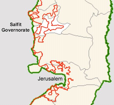
Extract from a UN-OCHA-map of the West Bank that shows the finished and the planned track of the wall as a red line. The governorate Salfit will loose about half of its territory.
To the harvest
Our trip into the Westbank started the next day at 1 pm at the bus station north of Damascus gate. I, for one, did not really know exactly where we were going. But we had a few instructions as to how to meet our group of German speaking olive pickers that was organized by the IWPS (International Women's Peace Service). Some of the group had been there for a while and were moving on that day to another location. We
drove north through the suburbs of
Jerusalem towards Ramallah until we reached the checkpoint Qualandya,
where we
transferred to a collective taxi. Before reaching Qualandya the bus
moved on side roads. From fellow travelers we learned that the main
road was just being torn up and destroyed to make room for the
'security' wall.
The
wall was built right in the middle of the road. The last stretch we
drove along the wall. It did not look 8 meters high to me.
Maybe there are lower sections.
We
drove north through the suburbs of
Jerusalem towards Ramallah until we reached the checkpoint Qualandya,
where we
transferred to a collective taxi. Before reaching Qualandya the bus
moved on side roads. From fellow travelers we learned that the main
road was just being torn up and destroyed to make room for the
'security' wall.
The
wall was built right in the middle of the road. The last stretch we
drove along the wall. It did not look 8 meters high to me.
Maybe there are lower sections.
 We
transferred into one of the orange-colored
taxis that was to take
us to the Checkpoint Zaatara. It is on the northern road going to
Nablus
which in Israeli maps is called Shchem. The peculiarity of this road
with the number 60 was not immediately evident to me. There were nice
big road signs in three different languages, often two of them, one for
the turnoff traffic and one for the continuing traffic. The designers
of the typical German miniature traffic signs could learn a lot.
We
transferred into one of the orange-colored
taxis that was to take
us to the Checkpoint Zaatara. It is on the northern road going to
Nablus
which in Israeli maps is called Shchem. The peculiarity of this road
with the number 60 was not immediately evident to me. There were nice
big road signs in three different languages, often two of them, one for
the turnoff traffic and one for the continuing traffic. The designers
of the typical German miniature traffic signs could learn a lot.
The names did not mean anything to me. Only later it became apparent
that no Palestinian places appeared. Just imagine one is leaving
Philadelphia and there is no Fort Washington, no Ambler, no Lansdale,
later may be Allengorod and in between may be a place like Georgij
after some well-known general of the occupation power.
We disembarked at the checkpoint and went to the agreed meeting point on the side road. I had problems with my mobile phone which had been freshly aquired for the trip. A Palestinensian offered his help. It turned out that he worked for VW in Nablus and often traveled to courses in Germany. This was possible with a special ID card issued by the German embassy.
After a while the group arrived in two collective taxis.
We
were
travelling west towards Salfit or Salfeet, the main city of
the district (see map below). After a short ride the trip ended. In
front of us there
were the remains of an earth wall that had been cleared away to the
point that we could have passed easily. However, on the other side were
taxis into which we had to transfer. For us newcomers this was
mysterious. But there was a simple explanation: The nonexistent block
could be passed by the orange-colored taxis with the green
licence plates. But this would have taken away the business for the
other taxis which can only travel on the inner side of the block (in
principle down to the settler road 505).
Remark: The road
block
was reinstalled
by the Israelis on Nov. 29, 2004
The road became a dirt road. The poor state of the road apparently was not due to lack of funds but rather due to restrictions by the occupation force. However, we had the 'bad luck' that one stretch of road was actually being repaired. No chance for a detour. So we had to see how to get through past the construction site with all our baggage. That was a rather complicated enterprise and took about an hour. The people in Salfit expecting us were becoming restless because it was the time of Ramadan, the Muslim month of fasting. Almost everybody had not drunk nor eaten anything during the whole day, and naturally they wanted to be home when the sun came down, which happened shortly after five o'clock, for the evening meal.
In contrast to the usual procedure to station the
international
helpers all in one location, it was agreed in Salfit for the helpers to
stay with families. Since the families that would need assistance would
possibly not be able to provide the sleeping facilities, basically
accomodation and support should have been possible with different
families, depending on the needs. It was apparently due to Ramadan that
this concept turned out not to be feasible, since some families were
not very eager to go into the groves during this time. In this way we
helped the families with which we were staying. Naturally these were
the families that were better of, in particular since everybody wanted
to host two males and two females, who, of course, had to stay in
separate rooms.
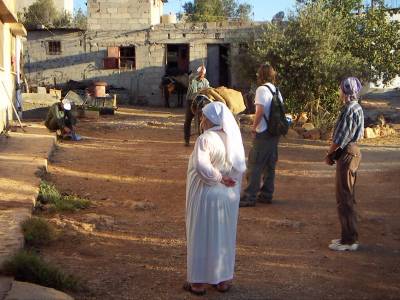
Sorting people out took place in the meeting room of a new multi
purpose building that also had the function of city hall. Everybody was
fairly tired and it took a while.
My group of four, one of them Sherrill, an American, who
remained
for a day, stayed with a farmer with ten adult children, six sons and
four daughters. As not unusual during the time of Ramadan, our host
family had a family gathering during the evening meal, 28 people. Men
and women ate in separate rooms and the oldest
son ate with us in a third room. Almond rice, chicken, a tasty soup,
salads and Arabic bread plus trimmings.
The sons were mostly employed, e.g. as a university professor, as a
teacher
or as a policeman. One son was imprisoned by the Israelis
for 280 years because he was supposed to have given his legal weapon to
a
terrorist. A pale portrait of him taken in prison was hanging above
the sofa, next to it one from better days.
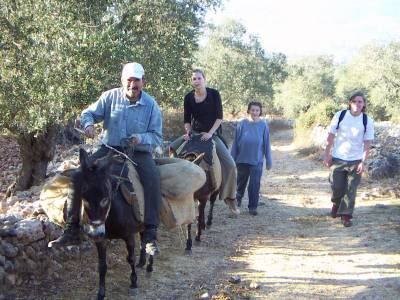
Departure in the early morning
In the foreground the farmer's wife. In the background the farmer is saddling his two donkeys.
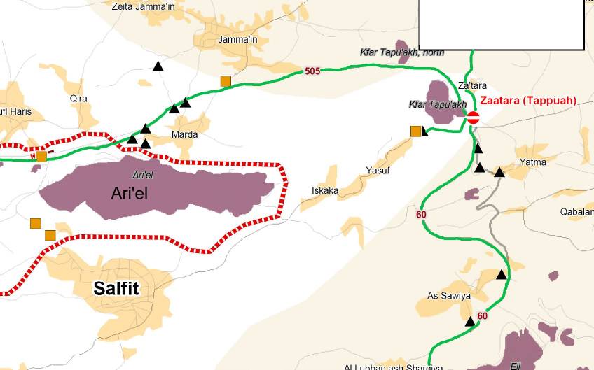
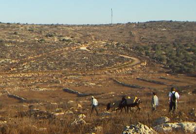
With this family we went into the olive grove for three and half days. The grove is located near the bordering fence of the large settlement Ariel, on the map half way between the planned wall and Ariel. This means that in the future it will be located inside the Ariel territory. The Israelis are very generous with their planning. Ariel is located on top of a hill range that stretches from west to east. Towards the south there is a valley with a few olive groves and otherwise only sparse natural growth. Further to the south is another range of hills where the town of Salfit begins. The planned course of the wall, for which the land has already partly been cleared, follows the top of this range.
On the way to the olive grove
The farmer had two donkeys which in the late afternoon,
grunting and
moaning, had to carry the harvest home. The path went up the hill
towards the north past the clearing for the wall and then down into
the valley at the bottom of which ran the bordering fence of Ariel, a
wire netting fence with barbed wire on the top. Near the olive groves
the
fence turns up the hill. Behind the fence is a dirt road that is used
by the Ariel security to run its patrol. The security guard is the
actual danger for the farmers. Three weeks
before we came the 'Security' had fired at the farmer with rubber
coated iron bullets in order to drive him away. These bullets are
potentially deadly.
The grove was located directly at the fence. The first day we did not notice any of the Ariel Security. Only late in the afternoon a man appeared behind the fence who was walking his dogs.
To the right the olive groves.
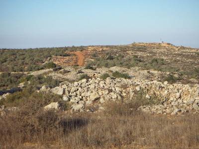
Approximately from the same position the view to the west on the rust brown clearing for the wall.
In the background to the right a military post.
The next day the Security cars came by quite often. On
the
third day
they sometimes stopped half way up the hill for a longer stretch
of time, so that we felt as if we were being observed. On that day we
also had a
visit from soldiers who marched up across the field with their weapons
dangling in front of them, while up on the hill towards Salfit a Hummer
vehicle approached that came down in serpentines. As it
turned out, they did not want anything from us. They were apparently
looking for somebody in the area. On the last day as we were getting
ready to leave there actually was some trouble with the 'Security' in
another grove up the hill closer to the settlement. It apparently had
to do with a horse tied up there – an unusually elegant
animal, by the way.
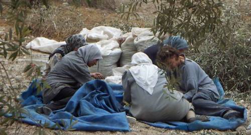
Olive harvest
|
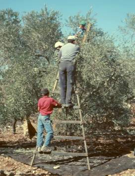 'Picking'
was done in different ways. The most
common way appeared to be picking by hand. Occasionally a small
rake with five coarse prongs was used. Finally there was a rather
brutal but apparently pretty efficient method, i.e. beating the olives
off the branches with a stick. Usually that method was only used in
places that were difficult to reach otherwise. It meant that quite a
few
leaves and twigs also came down and it was unpleasant for the
people working nearby, because they were bombarded with the olives.
'Picking'
was done in different ways. The most
common way appeared to be picking by hand. Occasionally a small
rake with five coarse prongs was used. Finally there was a rather
brutal but apparently pretty efficient method, i.e. beating the olives
off the branches with a stick. Usually that method was only used in
places that were difficult to reach otherwise. It meant that quite a
few
leaves and twigs also came down and it was unpleasant for the
people working nearby, because they were bombarded with the olives.